


Description
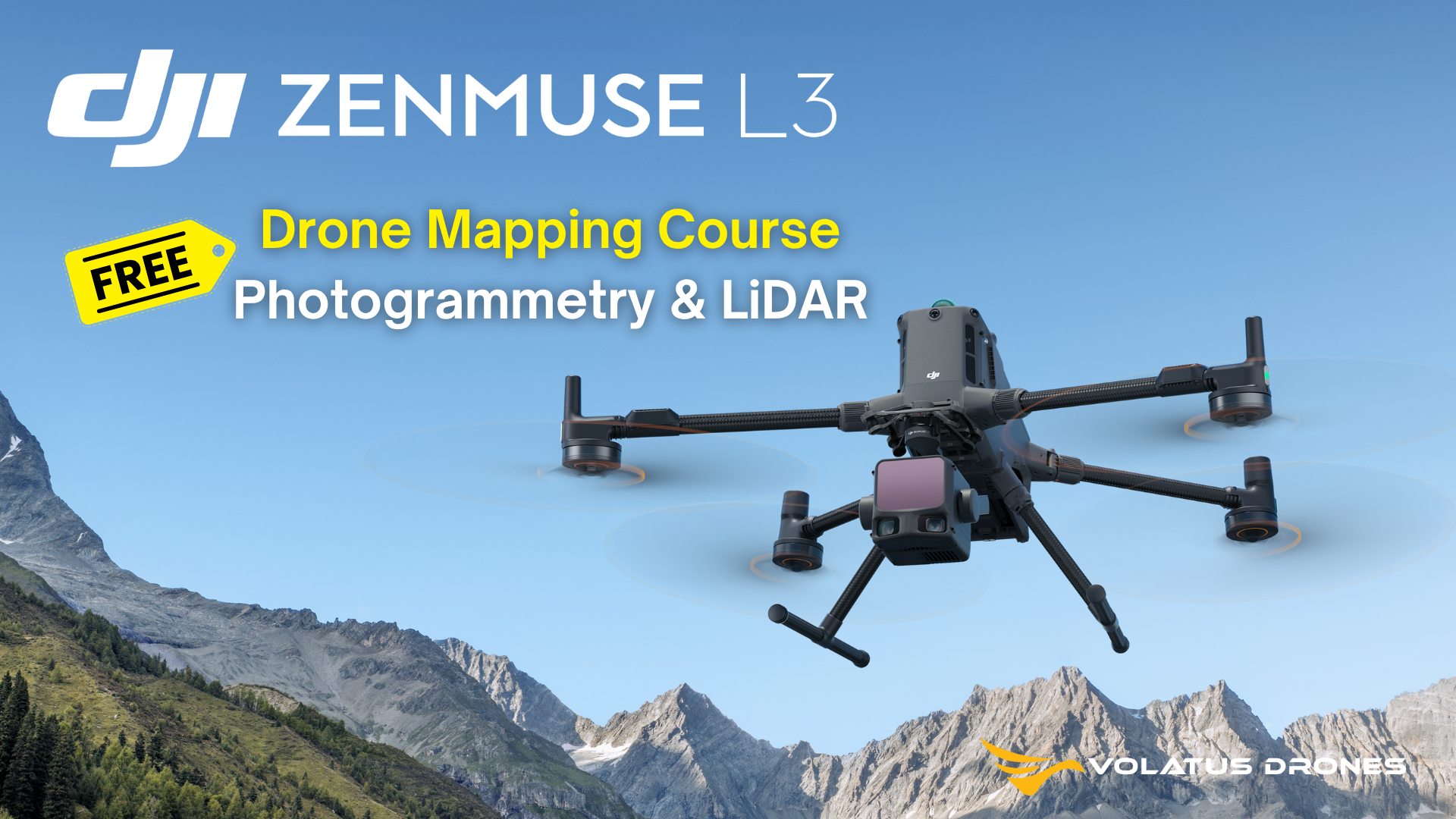
DJI Zenmuse L3
Get the Drone Mapping Fundamentals: Photogrammetry & LiDAR Course for FREE when you place your Zenmuse L3 order.
DJI is proud to introduce the new high-integration aerial LiDAR and camera system Zenmuse L3, designed for professional mapping, infrastructure inspection, forestry, and industrial applications.
The L3 combines an advanced LiDAR module with an improved detection range, a high-performance RGB camera (possibly 4/3-inch or full-frame sensor), a built-in high-precision IMU, and a 3-axis stabilized gimbal.
- Supports up to 5 (or more) laser returns and generates an even denser point cloud for penetration through vegetation and complex surfaces.
- Significantly extended detection range (e.g., 300–500 m for low-reflectivity targets) and improved vertical and horizontal accuracy (approximately 2–3 cm vertical, 3–4 cm horizontal), suitable for 1:1000-scale topographic mapping or better.
- Enhanced compatibility with Matrice RTK platforms and optimized workflow with DJI Terra software for seamless LiDAR data processing and photogrammetry.
- Increased reliability: improved IMU calibration, wider operating temperature range, and reduced module weight for easier integration and deployment.
- Ideal for large-scale mapping and survey missions — capable of covering extensive areas in one or two flights.
Application Scenarios
![]()

Proprietary High-Precision System
The upgraded high-precision POS system achieves heading accuracy of 0.02° and pitch accuracy of 0.01° (post-processed, 1σ). The self-developed LiDAR delivers ranging repeatability of 5 mm at 150 m (1σ) and supports microsecond-level time synchronization. Each unit undergoes rigorous factory calibration to ensure consistently reliable survey results.
LiDAR Data Accuracy
Vertical accuracy is better than 3 cm at 120m altitude, better than 5 cm at 300 m, and better than 10 cm at 500 m, easily supporting mapping projects at 1:500, 1:1000, and 1:2000 scales. The point cloud thickness produced by Zenmuse L3 is only half that of Zenmuse L2, supporting advanced analysis and high-accuracy applications.
Photogrammetric Accuracy
With dual 100MP RGB mapping cameras, Zenmuse L3 achieves a ground sample distance (GSD) of 3 cm even at a 300m flight altitude. Real-time position synchronization enables operation without ground control points (GCPs), ensuring high-quality imagery for precise mapping.
High Ground Point Density
With a smaller laser spot and higher single-pulse energy, Zenmuse L3 offers superior penetration capability. In terrain mapping and similar applications, it captures more ground points with greater completeness, significantly improving the accuracy and integrity of terrain data for precise surface fitting and reconstruction. Zenmuse L3 seamlessly integrates with DJI's ecosystem to deliver an end-to-end mapping solution. From data acquisition and processing to application, this unified workflow is simpler to operate and easier to master than traditional multi-platform setups, helping users efficiently complete a wide range of mapping tasks.
PPK Data Processing
DJI Terra features robust built-in PPK (Post-Processed Kinematic) capabilities, compatible with D-RTK 3 and standard base station data. The platform supports local PPK for RGB imagery and LiDAR, providing centimeter-level positioning accuracy even in areas with limited network connectivity or where RTK is unavailable.
Key Features
- 1535nm long-range LiDAR sensor for high penetration and accuracy
- Dual 100MP RGB mapping camera system
- Up to 100 km² daily coverage under optimal conditions
- High accuracy for professional mapping and surveying
- End-to-end solution for enterprise workflows
- Suitable for topographic mapping, vegetation analysis, and infrastructure inspection

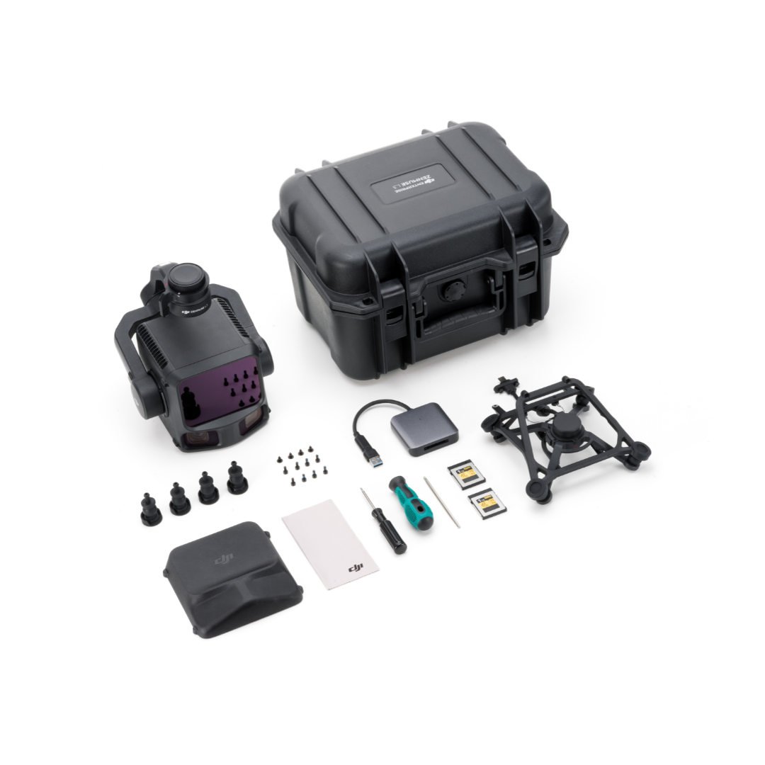
In The Box
DJI Zenmuse L3
- 1x Dji Zenmuse L3
- 1x Dji Zenmuse L3 Single Gimbal Connector
- 1x Dji Storage Case
- 4x Gimbal Dampers
- 2x CFexpress Type B Memory Card
- 1x CFexpress Type B Card Reader
- 1x DJI Matrice 400 Carrying Case Insert (Zenmuse L3)
- 1x Lens Cleaning Cloth
- Screws and Tools
Specifications
| System Specifications | Zenmuse L3 |
| System Specifications |
At 120m Flight Altitude: Vertical Accuracy: 3 cm (RMSE) Horizontal Accuracy: 4 cm (RMSE) At 300m Flight Altitude: Vertical Accuracy 5 cm (RMSE) Horizontal Accuracy: 7.5 cm (RMSE) Measured under the following conditions in a DJI laboratory environment 1. The field contained objects with obvious angular features. DJI Matrice 400 was linked to a position-calibrated D-RTK 3 Multifunctional Station. The flight route was planned using DJI Pilot 2's Area Route (with Calibrate IMU enabled) with Linear scanning. The flight speed was set to 15 m/s, gimbal pitch to -90°, and each straight segment of the flight route was less than 3300 m. 2. Using exposed hard ground checkpoints that conformed to the diffuse reflection model. 3. DJI Terra was used for post-processing with Optimize Point Cloud Accuracy enabled. |
| System Specifications |
1.2 cm@1σ (120m nadir flight altitude) 2 cm@1σ (300m nadir flight altitude) Measured in Linear scanning mode, using check points on 80% reflectivity objects, with neither point cloud optimization nor downsampling enabled in DJI Terra. For 6σ, multiply the listed thickness by 6. |
| System Specifications |
107° Composed by merging images from two cameras with a 45° optical axis angle between them. |
| System Specifications |
Average Value: 3 cm (300m nadir flight altitude) For detailed calculation methods, refer to the user manual available on the Downloads page of the official DJI Zenmuse L3 webpage. |
| System Specifications |
1.60 kg (without single gimbal connector) The Zenmuse L3 single gimbal connector weighs 145 g. |
| System Specifications |
192×162×202 mm (L×W×H) Measured in the default stabilized state after power-on with non-orthogonal gimbal design. |
| System Specifications |
64 W (typical) 100 W (max) |
| System Specifications | DJI Matrice 400 (requires the Zenmuse L3 single gimbal connector) |
| System Specifications | IP54 |
| System Specifications | -20° to 50° C (-4° to 122° F) |
| System Specifications | -40° to 70° C (-40° to 158° F) |
| LiDAR | 1535 nm |
| LiDAR | 0.25 mrad (1/e²) |
| LiDAR |
Φ 41 mm@120 m (1/e²) Φ 86 mm@300 m (1/e²) |
| LiDAR |
700 m@10% reflectivity, 350 kHz 950 m@10% reflectivity, 100 kHz 2000 m@80% reflectivity, 100 kHz 1. Range Definition: The range is defined as the distance at which 50% of the emitted laser pulses are detected. If a laser beam hits more than one subject, the total laser transmitter power is split and the achievable range is reduced. 2. Test Conditions: 100 klx ambient light, within the central area of the FOV, using a flat subject with a size larger than the laser beam diameter, a perpendicular angle of incidence, and an atmospheric visibility of 23 km. 3. The maximum detection range is 900 m by default. For a longer range, contact DJI support or an authorized dealer. |
| LiDAR |
21.6mm Steel Core Aluminum Stranded Wire: 300 m@100 klx, 350 kHz 18.4mm Black PVC Insulated Wire: 100 m@100 klx, 350 kHz 1. Range Definition: The distance at which a fully scanned section of wire in mapping achieves a point density of 4 points per meter. 2. Test Conditions: 100 klx ambient light, 23km atmospheric visibility, LiDAR center FOV perpendicular to the wire, Non-Repetitive scanning mode, drone flying along the wire at 15 m/s, and the wire is clean and not aged. |
| LiDAR |
Absolute Accuracy: ±10 mm Repeatability: < 5 mm (1σ) The above specifications can be met under test conditions of 25° C (77° F) ambient temperature, 350 kHz pulse rate, 80% object reflectivity, and distances of 120 m and 300 m. The actual environment may differ from the testing environment. The figure listed is for reference only. |
| LiDAR | 10 m |
| LiDAR | 0.8 m |
| LiDAR |
100 kHz, recommended flight altitude < 500 m 350 kHz, recommended flight altitude < 300 m 1000 kHz, recommended flight altitude < 100 m 2000 kHz, recommended flight altitude < 50 m |
| LiDAR |
4, 8, 16 returns (100 kHz, 350 kHz) 4, 8 returns (1000 kHz) 4 returns (2000 kHz) |
| LiDAR | 7 times |
| LiDAR |
Linear Scanning Mode: Horizontal 80°, vertical 3° Star-Shaped Scanning Mode: Horizontal 80°, vertical 80° Non-Repetitive Scanning Mode: Horizontal 80°, vertical 80° |
| LiDAR | Class 1 (IEC 60825-1:2014) |
| RGB Mapping Camera | 4/3 CMOS |
| RGB Mapping Camera |
Equivalent Focal Length: 28 mm FOV: 73.3° (diagonal), 62° (horizontal), 41.2° (vertical) Aperture: f/2.0-f/11 |
| RGB Mapping Camera |
Mechanical Shutter: 2-1/1500 s (f/2.0), 2-1/2000 s (f/2.8-f/11) Shutter Count: 500,000 Electronic Shutter: 2-1/16000 s |
| RGB Mapping Camera |
100 MP: 12288×8192 25 MP: 6144×4096 |
| RGB Mapping Camera |
JPEG: 25 MP: 0.5 s 100 MP: 1 s RAW or JPEG + RAW: 1.2 s |
| RGB Mapping Camera |
Video Format: MP4 (MPEG-4 HEVC/H.265) Resolution: 4K: 3840×2160@30fps FHD: 1920×1080@30fps |
| Position and Orientation System (POS) System | 5 Hz |
| Position and Orientation System (POS) | 200 Hz |
| Position and Orientation System (POS) |
Yaw Angle: 0.02° (post-processed, 1σ) Pitch/Roll Angle: 0.01° (post-processed, 1σ) |
| Position and Orientation System (POS) |
Horizontal Accuracy: 1.0 cm + 1 ppm (RTK fix) Vertical Accuracy: 1.5 cm + 1 ppm (RTK fix) |
| Position and Orientation System (POS) |
DAT: Generated in Base Station Mode by D-RTK 3 Multifunctional Station and D-RTK 2 RINEX: v2.1x, v3.0x RTCM: v3.0, v3.1, v3.2, v3.3 (protocols: MSM3, MSM4, MSM5, MSM6, MSM7) OEM: OEM4, OEM6 For field operation, ensure the distance between the Multifunctional Station and the aircraft does not exceed 15 km, and the Multifunctional Station supports satellite observation with more than two GNSS constellations. |
| Gimbal | 3-axis (pitch, roll, yaw) |
| Gimbal | ±0.01° |
| Gimbal |
Pitch: -135° to +73° Roll: -90° to +60° Yaw: -105° to +105° Structural limit, not controllable range. |
| Gimbal |
Pitch: -120° to +60° Yaw: -80° to +80° Roll is uncontrollable, for stabilization only. |
| Gimbal |
Roll Axis: Self-check not required Yaw Axis: Checks using limit stop Pitch Axis: Self-check not required |
| Gimbal | Detachable DJI SKYPORT (Zenmuse L3 single gimbal connector) |
| Data Storage | Photo/IMU/Point cloud/GNSS/Calibration files |
| Data Storage | CFexpress™ Type B Memory Card, sequential write speed 1500 MB/s |
| Data Storage | Read/write speed > 900 MB/s |
| Software Ecosystem | DJI Pilot 2 |
| Software Ecosystem | DJI Terra |
| Software Ecosystem | DJI Modify |
| Software Ecosystem | DJI FlightHub 2 |
| Software Ecosystem |
DJI Terra supports exporting point cloud models in the following formats: Standard Point Cloud Format: PNTS/LAS/LAZ/PLY/PCD/S3MB DJI Modify supports importing point cloud models in the following formats: Standard Point Cloud Format: LAS |
Paiement et sécurité
Vos informations de paiement sont gérées de manière sécurisée. Nous ne stockons ni ne pouvons récupérer votre numéro de carte bancaire.
NOS MARQUES PARTENAIRES


Nous sommes honorés d'avoir remporté des contrats avec Sourcewell et Canoe , améliorant ainsi l'efficacité des achats pour les organismes gouvernementaux, éducatifs et à but non lucratif en Amérique du Nord - Voir les détails
Tu pourrais aussi aimer
Vu récemment
FAQ
Oui, la livraison est GRATUITE partout au Canada pour les commandes de plus de 199 $. Pour les commandes de moins de 199 $, un tarif fixe de 25 $ est appliqué.
Le service de réparation est éligible à la livraison gratuite si la valeur de la commande est supérieure à 300 $.
Les délais de livraison dépendent de votre localisation et du mode de livraison choisi. Les délais de livraison estimés et les options de livraison sont indiqués au moment du paiement.
Si votre achat présente un défaut de fabrication, vous pouvez le retourner dans un délai déterminé, à condition qu'il soit inutilisé et dans son emballage d'origine. Nous ne prenons pas en charge les retours de pièces détachées.
En tant que distributeur agréé, nos produits bénéficient généralement d'une garantie fabricant couvrant les défauts de fabrication pendant une période déterminée. La durée et les conditions exactes peuvent varier selon le produit. Veuillez consulter la fiche produit pour plus d'informations.
Notre équipe d'assistance client est disponible pour vous aider en cas de problème technique ou de besoin de service. Contactez-nous simplement et nous vous guiderons dans la résolution de votre problème ou organiserons une intervention si nécessaire.
Oui, nous vous recommandons de consulter les consignes de sécurité fournies avec votre produit. De plus, assurez-vous de respecter la réglementation locale et les bonnes pratiques pour une utilisation sûre et appropriée.
Oui, nous proposons des précommandes pour certains produits à venir. La disponibilité des précommandes, les dates de sortie estimées et les offres exclusives sont indiquées sur les pages produits correspondantes.
Nous proposons des tarifs et une assistance spécifiques pour les clients professionnels ou les commandes groupées. Veuillez contacter notre équipe commerciale pour obtenir des devis personnalisés et des informations complémentaires.
Si vous avez encore des questions, vous pouvez nous contacter ci-dessous et nous vous répondrons dans les plus brefs délais.