Hovermap ST-X represents a leap forward in autonomous LiDAR mapping technology, delivering fast, accurate, and high-resolution 3D data capture across diverse environments. Combining advanced sensing, rugged design, and flexible deployment options, Hovermap ST-X enables professionals to efficiently collect detailed spatial information in both indoor and outdoor settings, even under challenging conditions such as GPS denial. Its innovative features improve project speed, safety, and data quality for applications including surveying, infrastructure inspection, and forestry.
Extend Your LiDAR Mapping Reach
With a sensing range of up to 300 meters and a capture rate exceeding one million points per second, Hovermap ST-X expands your coverage area while reducing flight time. Its ability to gather detailed data rapidly means fewer flights are needed, cutting setup and relocation periods and accelerating overall project completion.
Exceptional Indoor and Close-Range Accuracy
Hovermap ST-X excels with sub-centimeter accuracy indoors and at close range. This is achieved through the award-winning Wildcat SLAM solution, Automated Ground Control Points, and enhanced LiDAR sensor precision, producing cleaner, more precise point clouds for superior analysis and insights.
Versatility for Any Environment
The device offers unmatched flexibility: mount it on a drone for autonomous aerial scanning in GPS-denied or difficult locations, or detach it for handheld, backpack, or vehicle-mounted scanning modes. This rapid adaptability allows users to capture as-built data and digital twins in minutes instead of hours, regardless of the environment.
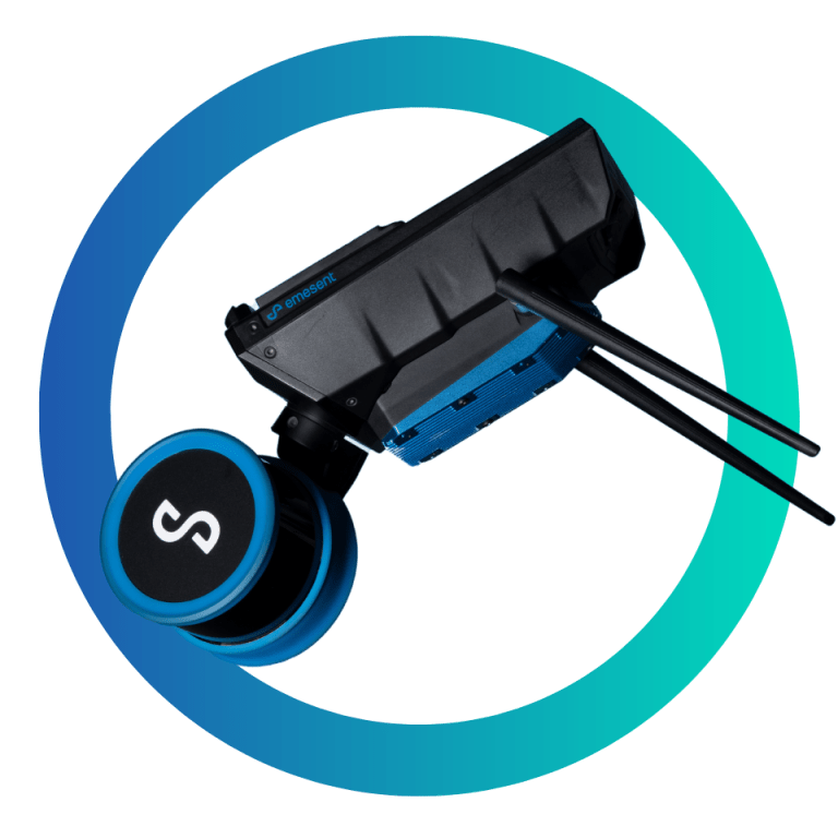
Rugged and Weather-Resistant Design
Built to endure, Hovermap ST-X features a lightweight yet rugged weather-sealed construction that resists dust, water splashes, and harsh conditions, enabling reliable operation above ground or underground, indoors or outdoors.
Advanced Vegetation Penetration
Equipped with triple return LiDAR and a rotating sensor, Hovermap ST-X provides excellent penetration through vegetation, making it ideal for terrain and forestry scans. The dense point clouds generated simplify object classification and improve data quality.
Real-Time Data Streaming and Extended Range
Users can view live streamed point clouds on a control tablet, allowing real-time assessment of scan progress. With the optional Long Range Radio accessory, connectivity extends up to twenty times farther, supporting control and data preview over long distances.
Multiple Autonomy Levels for Different Needs
Hovermap ST-X offers autonomy modes tailored to various missions. Mapping Mode delivers fast mobile scanning without drone autonomy. Pilot Assist Mode adds omnidirectional collision avoidance and GPS-denied flight control for safe close inspections. Autonomous Waypoint Mode enables fully autonomous, beyond-visual-line-of-sight flights with smart waypoints for guided exploration.
Enhanced Scanning with Colorization and Tap-to-Fly
Optional colorization adds true color to 3D point clouds, enriching visual context and revealing hidden infrastructure details. Using Tap-to-Fly autonomous waypoint planning, operators execute complex missions easily via tablet, flying beyond sight with integrated collision avoidance and smart Return-to-Home for safety.
In The Box
- 1x Emesent Data Processing Licence Key with Aura Lite Software
- 1x Hovermap ST-X
- 1x Hardcase for Hovermap
- 1x Battery
- 1x Handheld/Battery cable 1.5m (Fischer ST/STX to D-Tap Battery)
- 1x Drone/Battery cable 0.35m (Fischer to Fischer)
- 1x Cable Bag
- 1x Handle
- 1x Belt Clip
- 1x Standard Charger with 3 x international adaptor (US/Canada, AUS/NZ, Europe/Japan)
- 1x Hovermap Scanning Software USB
- 1x Quick Start Guide (printed)