

Description
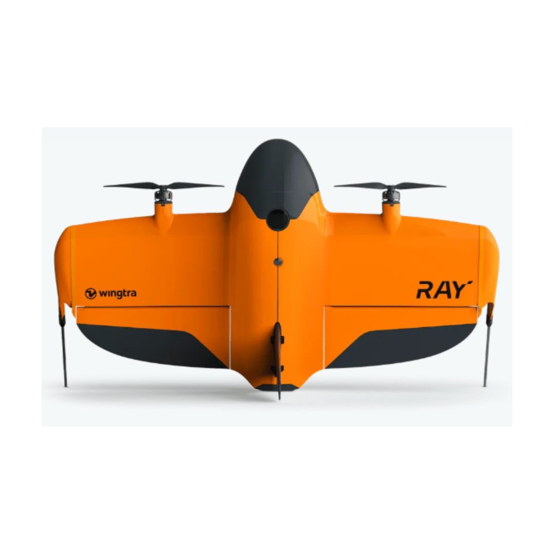
WingtraRay
WingtraRAY redefines aerial surveying by guaranteeing mission success on the very first flight, whether you’re navigating tight urban corridors or vast rural expanses, while dramatically cutting turnaround times and operational overhead. Its modular, all-in-one design scales effortlessly from millimeter-level inspections to large-area mapping, so you can serve more clients and tackle a wider range of projects with a single versatile platform.
- Peace of mind: Confidence you’ll get it right the first time, in rural and urban environments
- Cost Effective: The fastest most reliable way to deliver survey data
- One tool, more jobs: Serve more customers and applications, from fine detail and mm resolution to full-scale projects, with one solution

MAP61
Engineered for large‐scale, high-resolution 2D mapping and 3D modeling, the MAP 61 camera dramatically shortens mission time in the field. Thanks to its oblique 61 MP sensor, fast capture speed, and optimized image overlap, you can capture extensive areas in detailed 3D maps quickly without compromising on quality.
SURVEY61
For survey‐grade photogrammetry and high‐precision mapping, SURVEY61 offers a 61 MP nadir RGB sensor with a low distortion lens enabling aerial surveying in high resolution — featuring GSD down to 0.5 cm/px. Perfect for urban planning and construction, it provides survey-grade accuracy from 120 m AGL without the need of Ground Control Points (GCPs). Covering up to 310 ha at 120 m (1.3 cm/px GSD), it also ensures efficient data capture for projects of all scales while retaining exceptional detail.
INSPECT
When you need the highest resolution for close‐up inspections, INSPECT delivers. Its 61 MP nadir camera with fast trigger speed coupled with a high-quality tele lens enables millimeter‐level detail for critical infrastructure checks in railways, airfields, and similar applications down to 0.25 cm/px GSD. With coverage of up to 100 ha at 120 m (0.5 cm/px GSD), INSPECT outperforms other aerial solutions by factors in terms of field efficiency and delivers ultra‐sharp detail for thorough asset evaluations.

SURVEY24
The SURVEY24 payload is an accessible choice for organizations seeking accurate yet cost‐effective surveying solutions. With a nadir RGB sensor designed for photogrammetry, it offers good precision and covers up to 330 ha at 120 m (at 2.4 cm/px GSD). This balance of affordability and performance makes SURVEY24 well‐suited for general surveying tasks that demand reliable accuracy.
MicaSense RedEdge-P
A powerful multispectral payload for advanced vegetated area analytics, RE-P combines high‐resolution multispectral and RGB imaging in a single streamlined system. Its 5.1 MP panchromatic sensor, operating at up to three frames per second, reveals crucial details in forestry, agriculture, and environmental research, helping users track plant health, monitor crop productivity, and observe ecological changes. With a GSD down to 2 cm/px, RE-P delivers the precision and data quality needed for confident decision‐making in a wide range of green‐focused industries.
LIDAR
Capture detailed elevation data even through dense vegetation for advanced terrain modeling and topographical analysis with Wingtra's LIDAR sensor – a high-performance aerial scanning solution within a streamlined surveying workflow. With point densities up to 200 points/m², it excels in mining, construction, urban planning, and environmental monitoring.
Parachute add-on
For compliant operations overpopulated areas
Get access to survey populated areas - no paperwork or waiting time needed. WingtraRAY’s parachute enables compliant operations over people to eliminate the need for flight permits while ensuring on-the-ground safety.
- Unlocks access to survey 98% of US land without a waiver
- Expand accessible areas to survey by 2-3x
Product Details
The parachute is an easy-to-install add-on that comes with a manual trigger device. In the rare event every other backup, such as manual takeover or Return-to-Home, malfunctions, you can deploy the parachute manually, to safeguard people and property below. Each purchase also includes a one-year OOP (Operations Over People) license, ensuring immediate compliance in relevant regions.
Heavy-flyer add-on
Built for heavy flyers with large projects requiring multiple flights, this bundle ensures uninterrupted flying, even when mapping large projects. Deploy all-day operations thanks to three extra sets of batteries that allow for swift battery swaps, field charging equipment, and spare parts that ensure maximum uptime.
- Uninterrupted, all-day operations
- Cover large areas or multiple jobs in one day
Product details
The heavy-flyer bundle is an all in one easy to carry hardcase that contains everything you need to conduct multiple flights in one day with peace of mind: 3 sets of batteries, field charging equipment that connects to your car battery, 2 SD cards, 1 anemometer, 3 pairs of propellers, 2 landing gear fins, 1 screwdriver for drivetrain and parachute replacement.

Specifications
| Specifications | Details |
|---|---|
| Time to Map 100 Ha (250 ac) | 10 min |
| Coverage per Flight (59 min) | 1360 ac / 550 ha |
| Payload Capacity | 2.75 lb / 1,250 g |
| Telemetry (Radio + Cellular) | 2.5 GHz (6 mi / 10 km), LTE (Unlimited) |
| Flight Speed (Adaptive) | 36-49 mph (16-22 m/s) |
| Wind Resistance | Gust: 40 mph (18 m/s), Sustained: 27 mph (12 m/s) |
| Best Resolution @ 60m (200 ft) | 0.1 in/px (2.5 mm/px) |
| Absolute Accuracy @ 60m (200 ft) | 0.1 ft / 3 cm |
| Drone Type | Tailsitter vertical take-off and landing (VTOL) |
| Maximum Take-off Weight | 5.2 kg (11.5 lb) |
| Wingspan | 125 cm (4.1 ft) |
| Battery Capacity | Two 99 Wh batteries (pair required) |
| Battery Type | Lithium-polymer, smart battery tech, UN3481 compliant |
| Onboard GNSS | Dual/redundant GNSS (GPS L1/L2, GLONASS L1/L2, Galileo L1, BeiDou L1) |
| GNSS Frequency Range | 1227.6 MHz, 1242.9375–1251.6875 MHz, 1561.098 MHz, 1575.42 MHz, 1598.0625–1609.3125 MHz, 1602.00 MHz |
| Primary Radio Link | Bi-directional, 2.4 GHz, 10 km (6 mi) LOS |
| Secondary Radio Link | LTE, unlimited range with mobile coverage |
| Drone Dimensions | 125 × 68 × 12 cm (49.2 × 26.8 × 4.8 in) (without landing fin) |
| Transport Case Dimensions | 130 × 70 × 34 cm (51.2 × 27.6 × 13.4 in) |
| Transport Case w/ Shipping | 134 × 74 × 37 cm (52.8 × 29.1 × 14.6 in) |
| Weight (Case incl. drone) | 14.4 kg (32 lb) |
| Weight (Case fully loaded) | 18.6 kg (41 lb) |
| Operating Temperature | 10–40°C (50–104°F) |
| Ingress Protection (IP) Rating | IP53 |
| Take-off/Landing Space | 2 × 2 m (6.6 × 6.6 ft) |
| Safety Features | Certified parachute, obstacle avoidance, adaptive geofence |
| Battery Charger | 4-channel dock (110–240 V AC or 11–36 V DC) |
| Payload Options | 61 MP (MAP61, SURVEY61, INSPECT, SURVEY24), LiDAR (M2X), RedEdge-P multispectral |
| Transport Case Weight (Shipping, loaded) | 18.6 kg (41 lb) |
Payment & Security
Your payment information is processed securely. We do not store credit card details nor have access to your credit card information.
OUR PARTNER BRANDS


We are honored to have been awarded Sourcewell and Canoe contracts, enhancing procurement efficiency for government, education, and non-profit agencies across North America - View Details
You may also like
Recently viewed
FAQs
Yes, we provide FREE shipping across Canada for orders over $199. Orders under $199 have a flat rate of $25.
Repair service is eligible for free shipping if order value is over $300.
Delivery times depend on your location and the selected shipping method. Estimated delivery times and shipping options are provided at checkout.
If there are any manufacturing defects with your purchase, you may return the product within a specified period, provided it is unused and in its original packaging. We do not provide any returns on repairs parts.
As an authorized distributor, our products typically come with a manufacturer's warranty that covers manufacturing defects for a specified period. The exact duration and terms may vary by product. Please refer to the product details for more information.
Our customer support team is available to assist you with any technical issues or service needs. You can simply reach out to us, and we'll guide you through troubleshooting steps or arrange for service if necessary.
Yes, we recommend reviewing the safety instructions provided with your product. Additionally, ensure compliance with local regulations and best practices to ensure safe and proper use.
Yes, we offer pre-orders for select upcoming products. Pre-order availability, estimated release dates, and any exclusive offers are listed on the respective product pages.
We offer special pricing and support for business customers or bulk orders. Please contact our sales team for customized quotes and additional information.
If you still have any questions, you can contact us below and we will get back to you as soon as possible.