
Description
YellowScan Mapper
We recommend a balanced 10 m/s flight speed to benefit from Mapper point density while having good productivity. For example, flying at 70m AGL, 10 m/s, you will be able to map 10 ha in 3 minutes.

Next-Generation Integrated UAV Lidar System with Livox Technology
|
AGL Altitude |
System Precision |
System Accuracy |
Weight With Battery |
70 m |
2 cm |
3 cm |
1.5 kg |
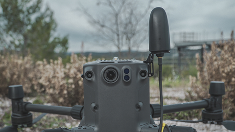
Livox Based LiDAR System
YellowScan Mapper UAV LiDAR system is equipped with a high-performance Livox Horizon laser scanner from Livox, a DJI-backed company. With a great point density, this LiDAR sensor allows our LiDAR system to fly easily at 70m AGL with a 120m swath.
We recommend a balanced 10 m/s flight speed to benefit from Mapper point density while having good productivity. For example, flying at 70m AGL, 10 m/s, you will be able to map 10 ha in 3 minutes.
YellowScan Mapper is definitely the right LiDAR tool to start with. Your data collection will be fast, accurate and cost-effective.
Connect your Mapper LiDAR system to your DJI Skyport.Designed for seamless integration with various UAVs including multirotor and fixed-wing drones. The integration options of Gremsy and DJI skyport, along with the custom mounting bracket, ensure a quick and convenient setup for rapid mapping operations.
|
|

 |
 |
High-quality GPS antennaThe GNSS antenna provided is able to receive superior signal from GPS L1/L2/L5/L-band, GLONASS G1/G2/G3, BDS B1/B2/B3, Galileo E5a/E5b/E6/E1. It has IP-67 protection from dust and water and a low wind-resistance design. High-quality GPS antenna is a must to get high-quality georeferenced point cloud. You deserve it. |
IP55 protectionYellowScan Mapper has IPW55 protection meaning rain is not an issue during data collection: you have time to land. You can start your flight without rain in a weather that “might forecasts rain”. If during the flight it starts raining, there is no issue flying back home. Your LiDAR is safe. The LiDAR system is equipped with non-slip rubber pads. You can lay your system down without fearing to damage it. |
 |
 |
Easily carry your mapping solution with a backpack!Let’s take advantage of this compact and lightweight LiDAR system. This time we thought it would be good having a backpack. In this hardshell backpack with custom precut foam, you easily carry your LiDAR with everything you need (LiDAR system, software, batteries, laptop, data storage). This backpack has carry-on size to fit in any airline overhead compartment. |
Don’t miss anything before going back to the office with Live Data transmission.In-flight LiDAR Data transmission is enabled by a dedicated port. The YellowScan Mapper is compatible with LiveStation, allowing live visualization of LiDAR data collection. Your mission has to be a success. |

Payment & Security
Your payment information is processed securely. We do not store credit card details nor have access to your credit card information.
OUR PARTNER BRANDS


We are honored to have been awarded Sourcewell and Canoe contracts, enhancing procurement efficiency for government, education, and non-profit agencies across North America - View Details
You may also like
Recently viewed
FAQs
Yes, we provide FREE shipping across Canada for orders over $199. Orders under $199 have a flat rate of $25.
Repair service is eligible for free shipping if order value is over $300.
Delivery times depend on your location and the selected shipping method. Estimated delivery times and shipping options are provided at checkout.
If there are any manufacturing defects with your purchase, you may return the product within a specified period, provided it is unused and in its original packaging. We do not provide any returns on repairs parts.
As an authorized distributor, our products typically come with a manufacturer's warranty that covers manufacturing defects for a specified period. The exact duration and terms may vary by product. Please refer to the product details for more information.
Our customer support team is available to assist you with any technical issues or service needs. You can simply reach out to us, and we'll guide you through troubleshooting steps or arrange for service if necessary.
Yes, we recommend reviewing the safety instructions provided with your product. Additionally, ensure compliance with local regulations and best practices to ensure safe and proper use.
Yes, we offer pre-orders for select upcoming products. Pre-order availability, estimated release dates, and any exclusive offers are listed on the respective product pages.
We offer special pricing and support for business customers or bulk orders. Please contact our sales team for customized quotes and additional information.
If you still have any questions, you can contact us below and we will get back to you as soon as possible.