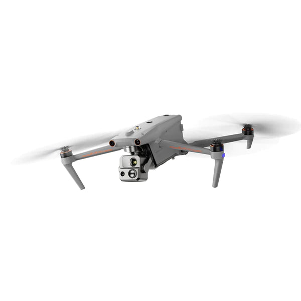
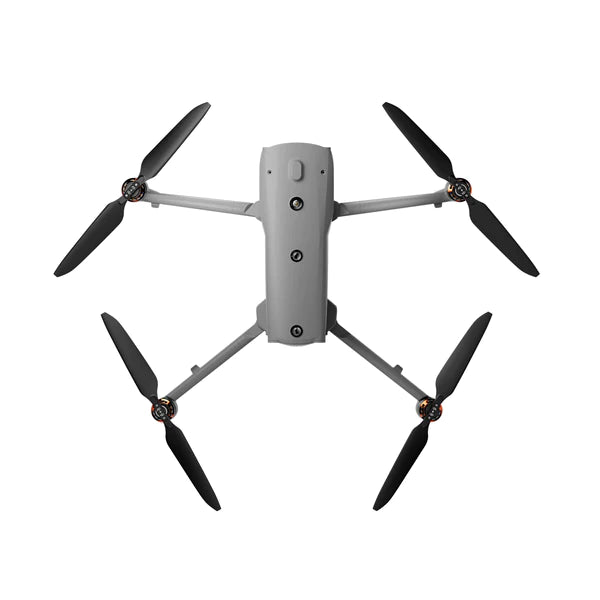
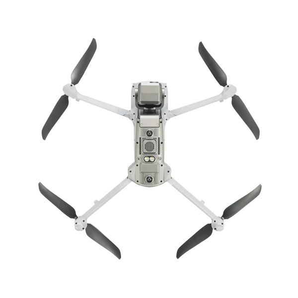
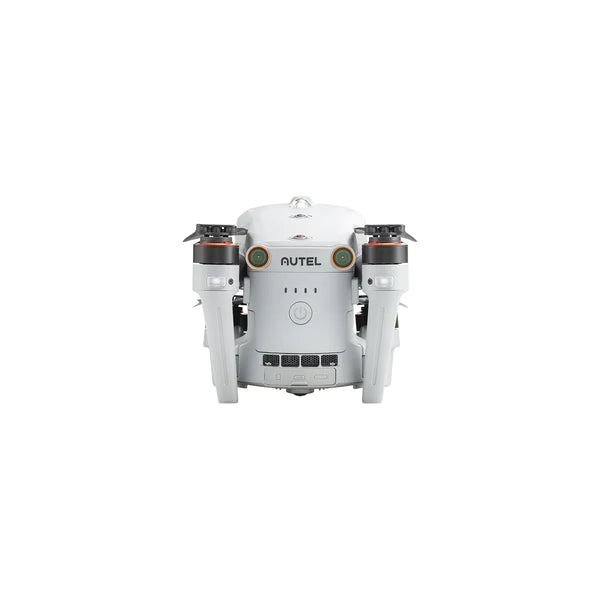
The EVO Max 4T brings powerful technologies and advanced autonomy to users. EVO Max 4T assesses complex environments to create real-time 3D flight paths for unparalleled obstacle avoidance.Advanced sensors make flight in GPS unavailable areas possible and the incredible new thermal payload unlocks new object identification and tracking scenarios.With a foldable, weather-resistant design, the EVO Max 4T is as portable as it is capable.
Accurate Object Identification and Tracking
Based on Autel's AI recognition technology, the EVO Max 4T can automatically identify and lock onto different types of targets such as heat sources, moving people, or vehicles and achieve high-altitude tracking and data collection for law enforcement.
Navigation in GPS Denied Environment
Advanced sensors allow the EVO Max 4T to navigate within hardened structures, underground, or in environments without GPS.
Autonomous Path Finding
Autel's Autonomy Engine collects surrounding environmental data and plans 3D flight paths through complex environments such as mountains, forests, and buildings. Use cases include rapid 3D scene reconstruction, public safety overwatch, industrial inspection, and land surveying.
Anti Jam, Anti Interference
The EVO Max 4T uses advanced flight control modules and algorithms specially designed to counter RFI, EMI, and GPS spoofing. This enables the EVO Max 4T to fly confidently near power lines, critical structures, and in complex areas.
Platform Capability
EVO Max 4T redefines portability with its powerful platform and all weather design.
Max. Flight Time: 42 mins
Weather Rating: IP43
Service Ceiling: 23,000 ft
Image Transmission Range: 12.4 miles
Max. Wind Resistance: 27 mph*
A-Mesh 1.0 - The Drone Industry's First Mesh Networking Technology
EVO Max 4T features the new A-Mesh system, enabling drone-to-drone autonomous communication, connection, and collaboration.
Strong Anti-Interference
The EVO Max 4T can communicate seamlessly with other drones in the vicinity, unlike a traditional chain structure. If a single drone fails or exits unexpectedly, the entire system will independently self-organize and continue to relay critical information.
Beyond-Line-of-Sight Applications
With A-Mesh, multiple aircrafts in the vicinity can act as relay points to greatly improve BVLOS operation effectiveness.
Full-Fleet Control
Multiple drones can be controlled autonomously by 1 pilot or by a group of pilots simultaneously with or without LTE coverage.
Enhanced Range
Communication nodes can be placed statically on hills or poles to provide full coverage to an area, or a swarm of drones can provide mobile communication points to extend the coverage of the entire group.
Autel SkyLink 3.0
The EVO Max 4T SkyLink 3.0 system comes with 6 antennas, 4 frequency bands, AES-256 encryption*, and optional 4G integration* to provide users with the most advanced flight capabilities ever in an EVO.
Image Transmission Distance: 12.4 miles
Latency: <150ms
Real-Time Image Quality: 1080p/60fps
Frequency Bands: 900MHz/2.4GHz/5.2GHz/5.8GHz**
*This feature will be available in a future update.
**5.2GHz is only applicable for FCC, CE, and UKCA regions. 900MHz is only applicable for FCC regions.
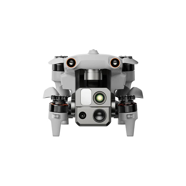
Mission Ready Payload
The payload integrates wide-angle camera, zoom camera, thermal camera and a laser rangefinder for all data capture needs and critical decision making.
Wide Camera: 50MP
Zoom Camera: 48MP
Optical Zoom: 8K 10x
Max. Hybrid Zoom: 160x
Thermal Resolution: 640x512
Supports for 8K 10x optical zoom, and 160x Max. Hybrid Zoom with clear details on targets up to 1.24 miles away.
Moonlight Agorithm 2.0 boosts postprocessing anp allows the pilot to capture crisp, detailed images in low-light environments.
support 4K 30fps, max ISO 64000
Moonlight mode reduces noise and enhances HDR
Equipped with 640*512 hightresolution thermal imaging camera, 30fps, and 16x digital zoom
Tap a target to get the coordinates and altitude rapidly from up to 0.75 miles away
Autel Enterprise App Platform
The Autel Enterprise App is built from the ground up for industrial applications and features a brand-new interface for simple, efficient operation. Additional features and semi-autonomous modes maximize the EVO Max 4T's mission capability.
Smart Features
3D Map Planning
Plan, create, and execute 3D waypoint mission plan on a 3D map.
Quick Mission*
Temporary quick missions can be created while executing other missions, and multiple sub-missions can be stacked for enhanced flexibility.
Mission Reproduction*
With this feature activated, fly a manual or semi-autonomous mission, or string multiple missions together. The EVO Max4T will automatically record the camera angles and replicate the mission you just flew
Multiple Mission Types
The Enterprise App provides various autonomous and semi-autonomous mission planning for public safety, inspection, and surveying.
*This feature will be available in a future update.
Terrain Follow*
Maintain a relatively constant altitude from the ground for uneven or sloped terrain.
Rectangular Mission
Supports one-click automatic generation of a rectangular flight area
Automatic Mission Generation And Data Capture*
Automatically produce routes by adding regional boundary points through dots or importing KML files
Waypoint Missions
Users can add waypoints for flexible, non-structured flight paths.
Oblique Photography
Automatically plan 5 groups of routes (1 ortho + 4 obliques) according to the flight area set by the user.
Spiral Mission*
Supports helical flight search in a designated area for SAR
Corridor Mission*
Supports intuitive and effective corridor mission planning for roads, rivers, pipelines, power lines, and other narrow, large-scale terrain.
Polygon Mission
Supports one-click automatic generation of polygon flight areas.
*This feature will be available in a future update.
Data Security
Privacy Protection: Data involving user and aircraft information, including flight logs, locations, and account information can only be physically accessed via the aircraft locally.
Encrypted Data Storage: Supports AES-256 encryption for photos, videos, and flight logs, which are password-protected.
Enhanced Live-View
Multi-channel Projection Screen*
Supports simultaneous output of RGB, infrared, night vision, and wide-angle images.
AR Scene*
Geo-location data and other aircraft location info detected by ADS-B can overlay on real-time map, which is convenient for users to confirm the drone's location and avoid airborne risks.
*This feature will be available in a future update.
Autel SDK
TheAutel SDKis open to the world, helping developers and partners reduce software and hardware development costs and jointly create a new industry ecosystem.
Mobile SDK
Open UX SDK (iOS&Android) can directly call up the ready-made interactive interface.
Payload SDK*
Unified interface standards support access to third-party mounts such as microphones and gas detectors.
Cloud SDK*
Enables remote live broadcast and control of drones and Nests through third-party platforms or web pages.
*This feature will be available in a future update.
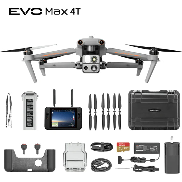
Accessories
Autel Smart Controller V3
Daylight Readable Display: 7.9 inches, 2000nit maximum brightness, 2048*1536 resolution.
Super download: Download footage from the drone to a mobile device at a maximum rate of 20MB/s.
Functional Interface: HDMI ports allow connection to 3rd party displays or monitors.
Ultra-Long Battery Life: Up to 4.5 hours of continuous operation. 2-hr fast charging from empty.
Local Storage: Built-in 128G storage space allows 3rd party apps and mission media storage.
Live Deck 2 (optional)
Broadcast live mission intel to other personnel in the operation for enhanced situational awareness and critical decision-making without the need for an LTE connection. The EVO Max 4T is compatible with Live Deck 2, which offers multiport streaming to monitors and Wi-Fi support for multiple local smartphones.
RTK Module (optional)
Provides centimeter-accurate positioning data for mapping and reduces electromagnetic interference for flying near critical structures.
Specifications
Aircraft
Weight
3.5 lbs (1600g, battery, and gimbal included)
Max. Takeoff Weight
4.41 lbs (1999 g)
Dimensions
576*660*149 mm (folded, incl. propellers) 340*407*148 mm (folded, excl. propellers) 257*136*133 mm (unfolded, excl. propellers)
Diagonal Wheelbase
1.52 ft (464mm)
Max Ascent Speed
8m/s
Max Descent Speed
6m/s
Max Horizontal Speed (windless near sea level)
23m/s
Max Service Ceiling Above Sea Level
23000ft (7000m)
Max Flight Time (windless)
42 mins
Max Hovering Time (windless)
38 mins
Max Wind Resistance
27mph* *Takeoff and landing can withstand wind speeds up to 27 mph (12 m/s).
Vertical: ±0.1 m (Vision System enabled); ±0.3 m (GPS enabled); ±0.15 m (RTK enabled); Horizontal: ±0.15 m (Vision System enabled); ±0.3 m (GPS enabled); ±0.1 m (RTK enabled);
Gimbal
Mechanical Range
Pan: -135° to 45° Tilt: -45° to 45° Roll: -45° to 45°
Indoor: Horizontal error ≤1.18in (At least have texture at one direction) Outdoor: Daytime: Within 1640ft (500m) flight height, horizontal error < 0.01*height Night: Manual flight is controllable within 328ft (100m) flight height
Non-GPS Return-to-Home
Within 1640ft (500m) flight height, horizontal error of Return-to-Home point < 11.81in
Automatic Obstacle Rerouting
High Speed Obstacle Rerouting: Flight speed up to 45mph (20m/s) when Min. safety distance to obstacle is 4.9ft (1.5m) High Precision Obstacle Rerouting: Flight speed could reach 6.7mph (3m/s) when Min. safety distance to obstacle is 1.64ft (0.5m)
Multi-target Recognition and Tracking
Target identification types: people, vehicles, boats Number of targets detected: 64 Comprehensive recognition accuracy: > 85%
Millimeter-wave Radar Sensing System
Frequency
60Ghz~64Ghz* *Please fly safely and consult your local laws and regulations.
Size
1.5*0.55*0.08 in (38*14*2mm) (L*W*H)
Weight
0.07oz (2g)
EIRP
18dBm
Sensing Range
Upward: 5.9~787.4in (0.15~20m) Downward: 3.9~4724.4in(0.1~120m) Forward and Backward (Standard/Comfortable): 0.82~98.43ft (0.25~30m) Forward and Backward (Standard/Comfortable): 0.82~98.43ft (0.25~30m)
41° F to 113° F (5ºC to 45ºC) When the temperature is lower than 10° C (50° F), the selfheating function will be automatically enabled. Charging in a low temperature may shorten the lifetime of the battery.
Hot Swap
Support
Payment & Security
Your payment information is processed securely. We do not store credit card details nor have access to your credit card information.
LifThor RC Pro for DJI RC Pro Controller erich s kirchhoefer (United States)
Lifthor tablet mount system for DJI RC Pro Controller
Excellently made product of cast aluminum and very strong... My only complaint is there was not much mention of the fact that you also need the XL tripod tablet holder to finish the job... but the showcased image of the LifThor mount "shows" the whole settup for $102 as if it all comes together and all you then need to to is hook up the necessary calbes (including the soecific USBc to HDMI adaptor cable and red HDMI to mini HDMI) and your done! Not true! You need to purchase that holder piece for about $19 plus shipping... THEN your set! But to me it's bad representation sho8bg a picture of a "mounted" tablet conjlnectec to the $102 part that nicely attaches to the RC Pro controller.... therefore... you either need to show a different picture... OR clealy state that the tablet holder piece is NOT included for the $102 and is separately sold and how to include and purchase it to create a complete set! Fair enough?