

Description
PIX4Dmatic Perpetual License
*All codes are final sale & non-refundable

Next-generation photogrammetry software for terrestrial, corridor and large scale mapping
*Software available in English, French, Japanese, Spanish, Simplified Chinese and Korean
Are you ready to go big?
The optimized software for the next surveying and mapping challenges.
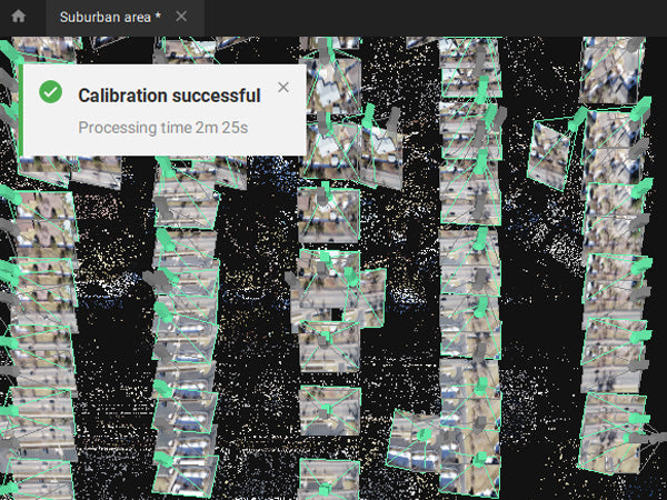
Bigger datasets, accurate results
PIX4Dmatic processes thousands of images while maintaining survey-grade accuracy, halving the processing time, without the trouble of splitting and merging.
Fully automated processing
Developed in close-collaboration with surveyors and mapping professionals to streamline your workflow: import, process and assess the quality of a project in just a few clicks, and move seamlessly from PIX4Dmatic to PIX4Dsurvey.
Terrestrial workflow
Leverage the benefits of both photogrammetry and LiDAR technology. Process LiDAR and RGB image outputs from PIX4Dcatch for a full terrestrial workflow. Easy and desktop-based.
Accurate 3D maps and models from thousands of images
Fast processing
Handling and processing large amounts of data is easy with PIX4Dmatic.
Get your results up to 50% faster, while keeping a survey-grade accuracy.


Essential outputs, in a fraction of the time without compromising accuracy
 Point cloud
Generate a dense point cloud, create a depth point cloud or fuse them according to the needs of your project and create the best reconstruction possible.
Export formats: .laz
 Orthomosaic
Create orthomosaics that are geometrically corrected such that the scale is uniform. They are color balanced in order to be visually pleasing.
Export formats: .tiff (GeoTIFF) .jpg (Georeferenced with .jgw)
 Digital surface model (DSM)
Generate a digital representation of all objects in the mapped area. It includes natural features as well as elevated objects, like buildings.
Export formats: .tiff (GeoTIFF)
 Mesh
Mesh
Compatible with PIX4Dsurvey
 Seamless export of processed projects into PIX4Dsurvey to transform point clouds into actionable CAD-ready data. Pix4D's proprietary .bpc file format is optimized for loading and manipulation of big point clouds.
PIX4Dmatic is changing the face of surveying and mapping

How to tidy point clouds with our sky filter
Check out how PIX4Dmatic uses machine learning algorithms to automatically identify and remove the sky in point clouds, and making outputs easier to analyze.

PIX4Dmatic 1.39: share to PIX4Dcloud and new mesh exports!
In PIX4Dmatic 1.39 you can now share to PIX4Dcloud, export your mesh in new file formats, and localize your site!
 Drones and airplanes: surveying an active airport
Mapping an active airfield can be incredibly dangerous. Discover how Quantum-Systems mapped the Valkaria Airport without startling pilots.
Payment & Security
Your payment information is processed securely. We do not store credit card details nor have access to your credit card information.
OUR PARTNER BRANDS


We are honored to have been awarded Sourcewell and Canoe contracts, enhancing procurement efficiency for government, education, and non-profit agencies across North America - View Details
You may also like
Recently viewed
FAQs
Yes, we provide FREE shipping across Canada for orders over $199. Orders under $199 have a flat rate of $25.
Repair service is eligible for free shipping if order value is over $300.
Delivery times depend on your location and the selected shipping method. Estimated delivery times and shipping options are provided at checkout.
If there are any manufacturing defects with your purchase, you may return the product within a specified period, provided it is unused and in its original packaging. We do not provide any returns on repairs parts.
As an authorized distributor, our products typically come with a manufacturer's warranty that covers manufacturing defects for a specified period. The exact duration and terms may vary by product. Please refer to the product details for more information.
Our customer support team is available to assist you with any technical issues or service needs. You can simply reach out to us, and we'll guide you through troubleshooting steps or arrange for service if necessary.
Yes, we recommend reviewing the safety instructions provided with your product. Additionally, ensure compliance with local regulations and best practices to ensure safe and proper use.
Yes, we offer pre-orders for select upcoming products. Pre-order availability, estimated release dates, and any exclusive offers are listed on the respective product pages.
We offer special pricing and support for business customers or bulk orders. Please contact our sales team for customized quotes and additional information.
If you still have any questions, you can contact us below and we will get back to you as soon as possible.