

Description
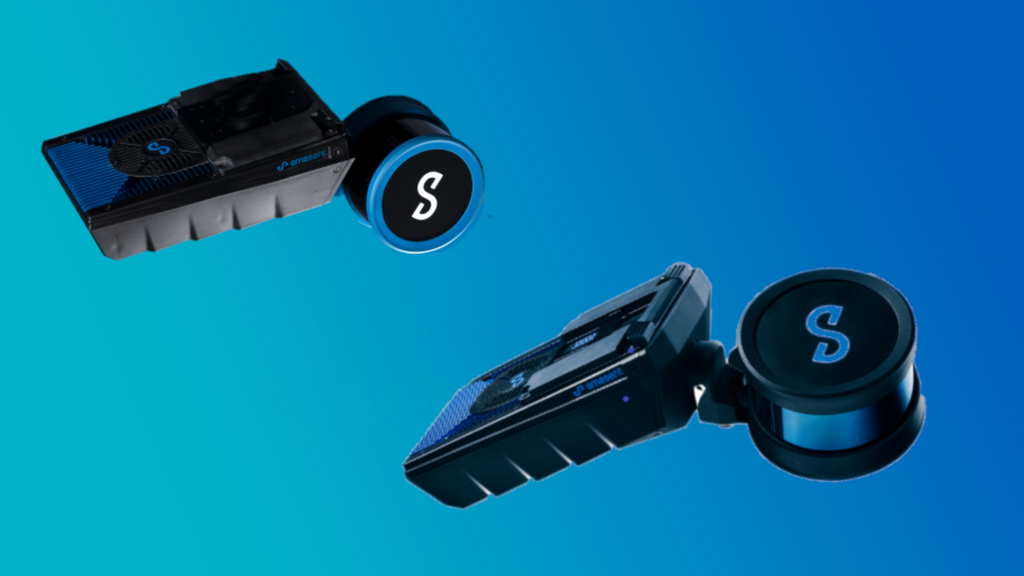
Emesent Hovermap Core
Designed for the needs of project-based survey teams, primarily working within the AEC industry, Hovermap Core offers a unique combination of hardware, software, and services. The Hovermap Core offering combines the high-performance capabilities of Emesent’s awardwinning Hovermap ST or ST-X systems with Emesent’s own data processing and visualization software, a mission planning and control app, and the potential to expand functionality as required.
Core delivers out-of-the-box survey-grade LiDAR capture, while allowing teams to add and extend capabilities and support as their needs change and grow over time. These include autonomous mapping via drone or robot (and related capabilities), point cloud colorization, automated Ground Control Points, and support for RTK GPS.
As a solution package, Hovermap Core includes:
- The option of either a Hovermap ST or ST-X
- Data processing and visualization software – Emesent Aura (v1.2.2)
- Mission planning and control app – Emesent Commander (v1.0)
- Emesent’s standard product warranty
- 1-year access to the Emesent Academy, software updates via the Customer Portal, and email support.
Hovermap Features
| Business Plans | ||||
| Core | Mapping | Plus | Autonomy | |
|
Versatile Hardware Scan locations without GPS by walking, driving or flying with the same hardware. |
✓ | ✓ | ✓ | ✓ |
|
No GPS Required Map any environment quickly and safely with Hovermap’s SLAM localization |
✓ | ✓ | ✓ | ✓ |
|
IP65 Rating IP65 rated unit is protected against dust and low-pressure jets of water from all directions, making it ideal for use in harsh environments. |
✓ | ✓ | ✓ | ✓ |
|
Obstacle Proximity Map* Use the proximity map to avoid obstacles and navigate the drone safely from a distance. |
✓ | ✓ | ||
|
Accessory Port An accessory port and mount points expand Hovermap ST’s capability with accessories such as a long-range radio. |
✓ | ✓ | ✓ | ✓ |
|
Drone Mountable* Attach the Hovermap payload to a compatible drone to use it as an all-in-one 3D mapping device. |
✓ | ✓ | ✓ | ✓ |
|
Smart Battery Return-to-Home Maximize flight time and return the drone to base safely using Hovermap’s battery monitoring and shortest route home features. |
✓ | ✓ | ||
|
Magnetic Interference Tolerance Maintain flight stability in areas of magnetic interference. |
✓ | ✓ | ||
|
Barometric Pressure Fly safely in tight spaces where air pressure fluctuates using the Hovermap SLAM altitude control feature. |
✓ | ✓ | ||
*Requires additional hardware to enable features
Hovermap Data Capture
| Business Plans | ||||
| Core | Mapping | Plus | Autonomy | |
|
Mapping only Rapid, high-definition survey-grade 3D data capture, in scenarios where autonomy is not required. |
✓ | ✓ | ✓ | ✓ |
|
GPS Denied Flight* Allows drones to fly autonomously in GPS-denied environments. |
✓ | ✓ | ||
|
Omnidirectional Collision Avoidance Create a virtual safety shield around the drone and avoid the smallest of obstacles. |
✓ | ✓ | ||
|
Real-Time Point Cloud Streaming View the 3D point cloud of your mapped environment in real time. |
✓ | ✓ | ✓ | ✓ |
|
Smart Waypoints Let the drone self-navigate to pre-set waypoints and monitor its progress via a live-streamed 3D map. |
✓ | |||
|
Beyond Visual Line-Of Sight Flight (BVLOS) Capture complex assets with a BVLOS Hovermap flight in GPS-denied environments. |
✓ | |||
|
Guided Exploration and Intelligent Path Planning Hovermap’s autonomous path planning algorithms guide the drone through its flight mission. |
✓ | |||
|
Tap-To-Fly Operation Fly an entire mission, from take-off to landing, with Hovermap’s easy to use interface. |
✓ | |||
|
Communication Loss Return-To-Home Minimize the risk from communications loss between the drone and Hovermap. |
✓ | |||
|
Live Stream Onboard Drone Camera* View a live stream of the mission with an integrated drone camera and Emesent software. |
✓ | ✓ | ||
|
Operate Beyond Communication Range Hovermap finds a safe route to a waypoint (continue beyond WiFi and radio communication ranges) before returning to home. |
✓ | |||
|
Extend your connectivity range up to 20 times* Long range radio enables users to live stream Hovermap point cloud data and control Hovermap from up to 20 times further. |
✓ | ✓ | ✓ | |
Aura Software, for Data Processing and Visualization
| Business Plans | ||||
| Core | Mapping | Plus | Autonomy | |
|
Responsive, Intuitive Command A new, intuitive and highly responsive touch screen interface delivers ease of navigation and smooth mission handling. Status indicators and active settings can be observed at a glance. |
✓ | ✓ | ✓ | ✓ |
|
Streamlined Mission Workflow Seamless guided workflow for both mapping and autonomous missions provides effortless control and execution. |
✓ | ✓ | ✓ | ✓ |
|
Advanced Navigation Hovermap automatically selects SLAM navigation to ensure optimal data capture and operation no matter the environment. |
✓ | ✓ | ||
|
Dust Filters Hovermap’s dust filtering capabilities allow safer, more confident autonomous flying in even the most challenging of environments. |
✓ | ✓ | ✓ | ✓ |
|
Obstacle Avoidance Commander’s Shield function delivers advanced obstacle avoidance with increased precision, accuracy and range. |
✓ | ✓ | ||
|
Notifications and Fail Safes Pre-mission checks ensure you are set up for scanning success, along with pop up notifications that keep you informed during the mission and provide guided prompts when action is needed. |
✓ | ✓ | ✓ | ✓ |
|
Live Point Cloud Visualization Live visualization with enhanced point cloud quality, clarity and depth perception. |
✓ | ✓ | ✓ | ✓ |
|
Environmental Handling Autonomy detects environmental hazards such as dense vapor clouds in underground mining stopes and prevents flight into them, keeping your device safe. |
✓ | ✓ | ||
|
Light Mode Greatly improves screen visibility in bright light environments, ensuring optimal contrast, readability and reducing eye strain. |
✓ | ✓ | ✓ | ✓ |
|
Plane Clipping Ideal for visualizing floor plan details of a building. Create top down or side on cross sections of your scan to expose greater detail or highlight areas of interest. |
✓ | ✓ | ✓ | ✓ |
|
Personalized Display Settings Easily adjustable settings for bright light environments, field of view, grid overlays, point cloud size, opacity and more. |
✓ | ✓ | ✓ | ✓ |
|
Task (Waypoint) Navigation Choice of optimized touch screen or drop-down menu options to set and edit tasks (waypoints) by column, point, height or planer, with improved visualization. |
✓ | ✓ | ||
*Requires an approved tablet to access features.
FAQ
What is included in the Core package?
Depending on your requirements of either a Hovermap ST or ST-X, ‘Core’ includes a Hovermap unit, Aura software, the Commander App and Technical Support. As an entry level product for Hovermap, Core offers more flexibility to project-based work.
Does the Core package include standard product warranty, maintenance and support?
Yes, Core includes a standard Hovermap warranty, and 12 months’ access to email support and regular software and firmware updates. Additional 12-month support coverage can be purchased at the end of the original period.
What happens after the initial 12 months?
You still retain use of your Hovermap unit and your processing license remains active. Based on your own requirements, you can choose to renew your support and maintenance plan. Optional Aura modules can be renewed (or added).
Once my Core support and maintenance lapses, can I renew?
Yes, you can. Support and maintenance can be renewed at any point.
Does the Core package include GCP, Colorization and RTK modules?
No. These are available separately as individual modules and each requires a separate purchase (with applicable hardware).
Can Core be upgraded?
Yes. A client who has purchased Core can choose to upgrade to either Mapping, Plus, or Autonomy packages, with each requiring an additional upgrade charge.
Payment & Security
Your payment information is processed securely. We do not store credit card details nor have access to your credit card information.
OUR PARTNER BRANDS


We are honored to have been awarded Sourcewell and Canoe contracts, enhancing procurement efficiency for government, education, and non-profit agencies across North America - View Details
You may also like
Recently viewed
FAQs
Yes, we provide FREE shipping across Canada for orders over $199. Orders under $199 have a flat rate of $25.
Repair service is eligible for free shipping if order value is over $300.
Delivery times depend on your location and the selected shipping method. Estimated delivery times and shipping options are provided at checkout.
If there are any manufacturing defects with your purchase, you may return the product within a specified period, provided it is unused and in its original packaging. We do not provide any returns on repairs parts.
As an authorized distributor, our products typically come with a manufacturer's warranty that covers manufacturing defects for a specified period. The exact duration and terms may vary by product. Please refer to the product details for more information.
Our customer support team is available to assist you with any technical issues or service needs. You can simply reach out to us, and we'll guide you through troubleshooting steps or arrange for service if necessary.
Yes, we recommend reviewing the safety instructions provided with your product. Additionally, ensure compliance with local regulations and best practices to ensure safe and proper use.
Yes, we offer pre-orders for select upcoming products. Pre-order availability, estimated release dates, and any exclusive offers are listed on the respective product pages.
We offer special pricing and support for business customers or bulk orders. Please contact our sales team for customized quotes and additional information.
If you still have any questions, you can contact us below and we will get back to you as soon as possible.